Search

Discover essential insights on food and nutrition for Type 1 Diabetes, from carb counting to meal planning.
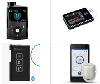
Pump Comparison tool . This easy-to-use updated comparison tool is designed to help you pick the right device for your family.

Websites we think you'll find useful.
Find out how to participate in our research and community groups.

T1D can be a traumatic diagnosis for children and young people, and often involves strict adherence to painful treatments, comorbid mental health conditions, and shortened life expectancy.
The DiabHQ Patient Portal app is now available to WA children and families living with Type 1 diabetes.

Building leadership includes two modules you can access using the links below. What is leadership? Leadership is the ability to influence the way
Once we’ve explored what it looks like to be an effective cyber leader, we can then begin to think about the sort of impact we want to make. Without
The leadership in action section of this handbook includes three modules you can access from the links below. How do you make a change? This module
The aim of every good leader is to make a positive change. It is often so easy to create lots of great ideas but how do we take that from a thought